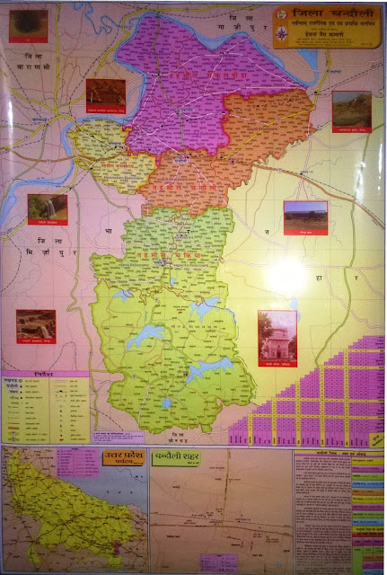
Chandauli : District Guide Map and Political Map
Introduction
This web-portal is an attempt to introduce Chandauli district as the whole, more specifically being informative, to all. It features historical background and known facts about Chandauli in History. It examines the geography, i.e. physiography, climate, soil, minerals and elements etc. It rejoices with cultural and literary heritage introducing personalities, places, customs, rituals, temples and ghats and fairs and gatherings as well. It focuses the informations beneficial to general citizen of the district, as the portal trying to list every school, college, hospitals, diagnostics, rail and bus stations, community centers, shops and malls and other places of general importance.
Services
Services
/fa-clock-o/ WEEK TRENDING$type=list
-
Chandauli : District Guide Map and Political Map
-
भूगर्भ, मृदा, टोपोलॉजी, जलवायु एवं प्राकृतिक वनस्पतियों के आधार पर जनपद निम्नलिखित क्षेत्रों में उप-वर्गीकृत किया जा सकता है- चकिया का प...
-
Official Calendar / Holiday List of Chandauli District for year 2017 is distributed for quick reference of holidays. It's posted here ...
-
Established by an order of Uttar Pradesh government on Sunday, May 25, 1997 Chandauli has a rich demographical character. It has three T...
-
We've previously put some statistics of district Chandauli here from the source of official website of NIC Chandauli and now we have ...
-
Chandauli is situated on the bank of holy river Ganga with the spread of 1889.9 S/km and bordered with the adjacent state Bihar in east, Va...
-
The District Chandauli was come in the existence in 1997 with the order-consent of the then-chief Minister of the state Sushri Mayawat...
-
The District Chandauli is located in 24° 56' to 25° 35' to north and 81° 14' to84° 24' east at a distance of about 30 kms ...
-
Census 2011 Details of Chandauli District A sticker pasted at a house to mark it 'counted' in Census of India 2011 C...
RECENT WITH THUMBS$type=blogging$m=0$cate=0$sn=0$rm=0$c=4$va=0
- At A Glance
- Banking Services
- Bhojpuri
- Business
- Calendar
- Census-2011
- Chakia
- Chandauli District
- Chandauli Mahotsava
- Commerce
- Communication
- Crops
- Culture
- Economy and Agriculture
- Events
- Ganga
- Guide Map
- History
- History and Geography
- Holiday List
- Industry
- Introduction
- Literature
- Major Banks
- Naugarh
- Personalities
- PIN Code
- Places
- Poet
- Political Map
- Post Offices
- Postal Services
- Ramnagar Industrial Estate
- Services
- Slider
- Tehsil
- ver
RECENT$type=list-tab$date=0$au=0$c=5
- At A Glance
- Banking Services
- Bhojpuri
- Business
- Calendar
- Census-2011
- Chakia
- Chandauli District
- Chandauli Mahotsava
- Commerce
- Communication
- Crops
- Culture
- Economy and Agriculture
- Events
- Ganga
- Guide Map
- History
- History and Geography
- Holiday List
- Industry
- Introduction
- Literature
- Major Banks
- Naugarh
- Personalities
- PIN Code
- Places
- Poet
- Political Map
- Post Offices
- Postal Services
- Ramnagar Industrial Estate
- Services
- Slider
- Tehsil
- ver
REPLIES$type=list-tab$com=0$c=4$src=recent-comments
- At A Glance
- Banking Services
- Bhojpuri
- Business
- Calendar
- Census-2011
- Chakia
- Chandauli District
- Chandauli Mahotsava
- Commerce
- Communication
- Crops
- Culture
- Economy and Agriculture
- Events
- Ganga
- Guide Map
- History
- History and Geography
- Holiday List
- Industry
- Introduction
- Literature
- Major Banks
- Naugarh
- Personalities
- PIN Code
- Places
- Poet
- Political Map
- Post Offices
- Postal Services
- Ramnagar Industrial Estate
- Services
- Slider
- Tehsil
- ver
RANDOM$type=list-tab$date=0$au=0$c=5$src=random-posts
- At A Glance
- Banking Services
- Bhojpuri
- Business
- Calendar
- Census-2011
- Chakia
- Chandauli District
- Chandauli Mahotsava
- Commerce
- Communication
- Crops
- Culture
- Economy and Agriculture
- Events
- Ganga
- Guide Map
- History
- History and Geography
- Holiday List
- Industry
- Introduction
- Literature
- Major Banks
- Naugarh
- Personalities
- PIN Code
- Places
- Poet
- Political Map
- Post Offices
- Postal Services
- Ramnagar Industrial Estate
- Services
- Slider
- Tehsil
- ver
/fa-fire/ YEAR POPULAR$type=one
-
Chandauli : District Guide Map and Political Map
-
भूगर्भ, मृदा, टोपोलॉजी, जलवायु एवं प्राकृतिक वनस्पतियों के आधार पर जनपद निम्नलिखित क्षेत्रों में उप-वर्गीकृत किया जा सकता है- चकिया का प...
-
The District Chandauli is located in 24° 56' to 25° 35' to north and 81° 14' to84° 24' east at a distance of about 30 kms ...
-
Stormy water after heavy rain on hill-side of Naugarh Climate of the district is almost of the subtropical monsoon type. The month of ...
-
प्रशासनिक उद्देश्य से चन्दौली जनपद का निर्माण वाराणसी जनपद से अलग करके 1997 में हुआ। यह जनपद पवित्र गंगा नदी के पूर्वी और दक्षिणी दिशा क...
-
Chandauli is situated on the bank of holy river Ganga with the spread of 1889.9 S/km and bordered with the adjacent state Bihar in east, Va...
-
Established by an order of Uttar Pradesh government on Sunday, May 25, 1997 Chandauli has a rich demographical character. It has three T...
-
Census 2011 Details of Chandauli District A sticker pasted at a house to mark it 'counted' in Census of India 2011 C...
-
The District Chandauli was come in the existence in 1997 with the order-consent of the then-chief Minister of the state Sushri Mayawat...
Business
Business


COMMENTS